Grid and Location Summary Reports
The Speed Survey Analysis System is more than just a database for maintaining
speed survey records. Used as an analytical tool, the program can help traffic
engineering departments and cities determine if speed limit changes are necessary
and to understand speed patterns for specific locations.
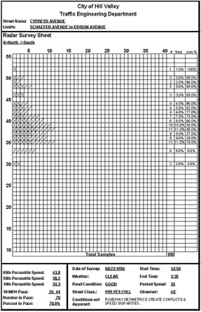
The Grid Report displays a grid of all inputted speeds, listing the total for each speed, the percentage of the aggregate total each speed represents, and the cumulative percentage for each speed. The cumulative percentage provides information for the 85th, 50th, and 15th percentile speeds, which help agencies determine whether or not a speed limit change is needed. Survey details are displayed at the bottom of the report (for a closer look, click here).
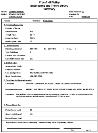
The Location Summary Report summarizes all the survey data for a specific location and breaks them into categories, including Prevailing Speed Data, Collision History, Traffic Factors, Conditions Not Readily Apparent, and Adjacent Land Use. The Location Summary Report includes percentile and pace information, as well as collision data.
The System can also produce Grid and Location Summary Reports for all locations in the database.
Summary Spreadsheet
The Speed Survey Analysis System also offers a Summary Spreadsheet, which
is a printable spreadsheet report of all the speed survey locations in the
system. The report includes location, date, direction, 50th and 85th percentile
speeds, accident rate information, and posted and new speed limit changes.
Highlight on GIS Map
When used in conjunction with the Traffic Collision Database, the Speed Survey
Analysis System can highlight speed zones on an editable GIS map of your city.